


16. To create the 3D map, press the 2nd button on the left of the "3D Map Control" box.
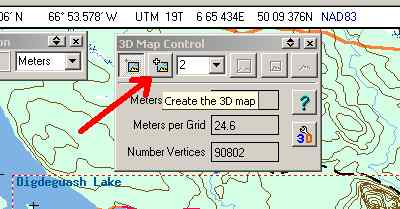
OziExplorer will now create the map and automatically open the 3D add-on. THIS MAY TAKE A FEW MINUTES IF YOU HAVE A SLOW COMPUTER! There will be a few "nag" screens that appear when you first open the 3D application; just click on the check boxes to keep them from appearing again.
17. You should now see the following or something like it.

If you can't see the "Map control" press the button shown by the red arrow. If the map control is just a narrow title bar press the "^" button next to the "x" button on the bar. To see the map image larger, press the button shown by the blue arrow. To move the map control around, just grab the title bar with your mouse by clicking on it and drag it where you want then release. I like to exaggerate the height factor of the maps I create to make things more visible. By pressing on the buttons shown by the yellow arrows features will get larger or smaller...a setting of 3.5 usually is pretty good for the relatively flat areas around here.
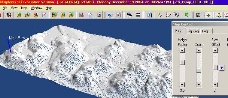
To change the angle or rotation of the map, place your mouse by the image and left-click and hold. The map will turn into a wireframe (above) - move your mouse around while holding the left button until it's where you want, then release. To move the image left or right or forward or reverse, right-click your mouse and hold then move.
Play around with the various buttons on the toolbar to see what they do. You can also save your map by clicking on "File", "Save 3D Map". When you are finished, close the 3D program.
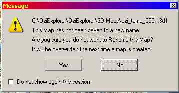
You'll see the above warning screen. Just click "Yes" if you don't want to save the 3D map. Ozi3D will close and you will return to OziExplorer.
I hope you have found this tutorial informative and useful. This is by no means a complete review of all the features provided by OziExplorer. Using a GPS it is capable of moving-map displays, waypoint and track overlay on map images, and many more useful functions. Play around with the programs and if you like them, BUY THE FULL VERSION! Help support the efforts of the brilliant people who have given us these great products.
Ron Boyce, 2004